Enregistrez gratuitement cette image
en 800 pixels pour usage maquette
(click droit, Enregistrer l'image sous...)
|
|
Réf : T01174
Thème :
Terre vue de l'espace - Plaines - Plateaux - Vallées - Général (487 images)
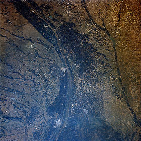
Titre : Central Nebraska, U.S.A. August 1989
Description : (La description de cette image n'existe qu'en anglais)
The dark agricultural lands of the Platte River Valley are apparent in this west-looking, low-oblique photograph. The Platte River flood plain in this region is more than 10 miles (16 kilometers) wide. Kearney (near the center) is a commercial, industrial, and transportation center in this agricultural area. Products include farm and irrigation equipment. Near the present city of Kearney, Fort Kearney was established in 1848 to protect settlers moving westward on the Oregon Trail; the fort was abandoned in 1871. East of Kearney on the Wood River near its junction with the Platte River is Grand Island, a major manufacturing and shipping center for this livestock, grain, and dairy region of central Nebraska. South of Grand Island is Hastings (barely discernible). Visible to the south of the Platte are the Republican River, and to the north are portions of the Sand Hills.
|
|

